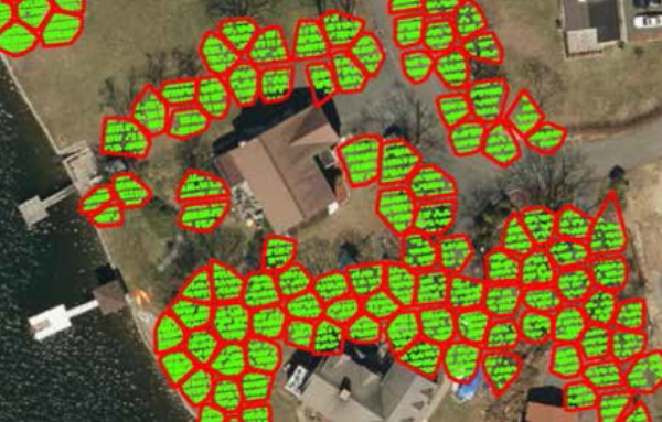
FirstLight Power Resources Services’ (FirstLight’s) Housatonic River Project Shoreline Management Plan requires the licensee to maintain a 50% vegetated buffer throughout the 50-foot band upslope of the waterline on all projects lands. In 2017, they sought assistance with the development of a survey method to establish baseline vegetated conditions on all project lands. With approximately 1066 acres of upslope land along188 miles of shoreline in five projects on the Housatonic River, traditional survey methods were deemed too expensive and impractical, thus a remote sensing solution was sought.
Kleinschmidt’s remote sensing team implemented state-of-the-art techniques to identify vegetative cover from leaf-off Light Detection and Ranging (LiDAR) data and quantified its extent. Kleinschmidt developed two approaches to delineate tree canopy and identify ground cover and low-vegetation (< 5 feet high). The tree canopy algorithm mathematically stretched the high vegetation LiDAR returns, allowing an unsupervised classification algorithm to easily identify and delineate individual tree crowns. Our low-vegetation cover identification method subtracted the last LiDAR returns representing the ground elevation from the first LiDAR returns that represented the tops of buildings and vegetation. Kleinschmidt conducted field verification of the results which indicated that low vegetation occurs in areas where the difference between surfaces was less than or equal to 5 feet.
As part of ongoing maintenance and monitoring activities at the Housatonic Project, FirstLight will routinely capture LiDAR data, meaning Kleinschmidt’s methods can be employed in the future to track the amount of vegetative cover through time. Our method eliminates the need for traditional, and costly, surveys of the shoreline. Using our LiDAR techniques, the only ongoing cost for vegetation monitoring will be to run the algorithms and interpret results.

Regional Vice President
Kevin Cooley, P.E.
Kevin Cooley specializes in the evaluation, planning, design, and rehabilitation of hydroelectric projects. He has been with Kleinschmidt for over 24 years and is currently Regional Vice President of the Northeast US and Canada, formerly serving as Director of Kleinschmidt’s Engineering Division. As Regional Vice President, Kevin is responsible for Kleinschmidt’s project execution in the...